

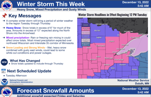
 Good morning, Bois Forte!Confidence is high in a high-impact winter storm this week with wet and heavy snow, beginning tomorrow and evening. The worst conditions will occur Tuesday night through the day Wednesday, but off-and-on snowfall will continue through the end of the work week. Winter Storm Warnings and Winter Weather Advisories remain in effect. Please see the attached PDF for more details.KEY MESSAGES————————-* A complex wintry storm arrives Tuesday, with the worst conditions on Wednesday.* High confidence that MOST of the Northland will see 6+ inches, with amounts of 1-2 feet expected along the North Shore.* Snow will be very wet and heavy leading to a large snow load on trees and powerlines.* Travel conditions will be extremely difficult on Wednesday, especially for the morning commute. Travel conditions may become impossible through the day Wednesday along the North Shore.RECENT CHANGES———* Snow totals were updated to include snowfall on ThursdayNEXT BRIEFING SCHEDULED—————* Tuesday afternoonUseful Links—————-NWS Duluth Website: https://www.weather.gov/dlh/NWS Duluth Facebook Page: https://www.facebook.com/NWSDuluthNWS Duluth Twitter: https://www.twitter.com/NWSDuluthHourly Forecast Details (Experimental): https://www.weather.gov/forecastpointsIf you have any questions, you can reply to this email or reach us directly by phone 24×7 at 218-729-0653.Thank you,Krystal, Linda, and the Team at NWS Duluth,
Damon Day, Bois Forte Emergency PreparednessNational Weather Service, Duluth, MNhttps://www.weather.gov/duluth